04/26/1884 • 7 views
First Known Photograph of a Tornado Captured, 1884
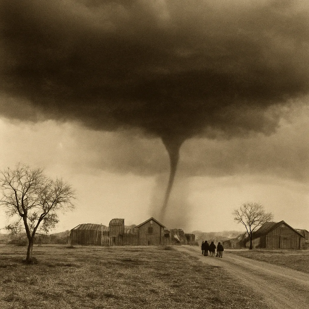
On April 26, 1884, the earliest surviving photograph commonly identified as a tornado was taken in Kansas, providing a rare visual record of a cyclone at a time when meteorology and photography were both rapidly advancing.
Photography in the 1880s required deliberate preparation: dry-plate negatives and large-format cameras limited spontaneous shots. That constraint makes any authenticated 19th-century image of a fleeting meteorological event noteworthy. The 1884 Holton photograph shows a slender, funnel-shaped formation extending from a storm cloud toward the ground. Contemporary and later commentators have treated it as a tornadic funnel, though some modern historians note that precise classification from a single black-and-white photograph can be uncertain.
The photograph's significance lies partly in what it represents for science and public awareness. In the late 19th century, systematic study of storms was developing. The U.S. Weather Bureau (established in 1870) and university researchers were beginning to collect observations, and visual records such as photographs complemented written reports and barometric readings. Images like the 1884 scene helped the public and scientists alike better visualize severe weather structures that were otherwise described in words or seen only fleetingly in the field.
Historical context is important. Tornadoes were well known to Midwestern residents, but scientific understanding of their structure, formation, and lifecycle was limited. Early photography occasionally captured storm phenomena, but technical limits—long exposures, bulky gear, and the difficulty of safely positioning near a storm—meant that many images are indistinct or ambiguous. This makes surviving, identifiable photographs from the era particularly valuable to historians of meteorology and photography.
Scholars approach the 1884 image with careful caveats. Photographic evidence alone rarely yields a full meteorological diagnosis: wind field, rotational velocity, and damage path require additional observations. Therefore, while the image is commonly described as the first known photograph of a tornado, some writers qualify that description by noting the possibility that the formation could be a funnel cloud that did not touch down, or that the date and provenance in some archival records are imperfectly documented.
Surviving prints and negatives of early storm photographs often reside in local historical societies, university archives, or collections focused on weather history and photography. Researchers cross-reference photographic archives with contemporary newspaper accounts, weather logs, and eyewitness reports to establish context. For the 1884 Holton image, such cross-referencing supports its dating to April 26, 1884, and its provenance in northeastern Kansas, though not every archival note is exhaustive.
The broader importance of early tornado photography is cultural as well as scientific. Visual records influenced how communities remembered and narrated catastrophic storms, and they provided material for newspapers and periodicals that reported on weather events. Over time, the accumulation of photographs has aided retrospective studies of tornado frequency, morphology, and societal impact, even as historians remain cautious about drawing meteorological conclusions from single images.
In summary, the photograph taken on April 26, 1884, near Holton, Kansas, stands as a notable early visual record commonly identified as a tornado. It sits at the intersection of emerging meteorological science and the maturation of photographic technology, and while it is treated as the earliest surviving example by many accounts, historians emphasize careful qualification when interpreting a single 19th-century image.